


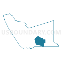
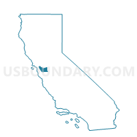
Voting District 10345, Alameda County, California
About
Outline

Summary
| Unique Area Identifier | 528644 |
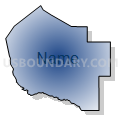
| Name | Voting District 10345 |
| County | Alameda County |
| State | California |
| Area (square miles) | 57.03 |
| Land Area (square miles) | 56.27 |
| Water Area (square miles) | 0.76 |
| % of Land Area | 98.67 |
| % of Water Area | 1.33 |
| Latitude of the Internal Point | 37.54301280 |
| Longtitude of the Internal Point | -121.77437650 |
Maps

Graphs
Select a template below for downloading or customizing gragh for Voting District 10345, Alameda County, California


Neighbors
Neighoring Voting District (by Name) Neighboring Voting District on the Map
- Voting District 10015, Santa Clara County, CA
- Voting District 10130, Alameda County, CA
- Voting District 10145, Alameda County, CA
- Voting District 10225, Alameda County, CA
- Voting District 10230, Alameda County, CA
- Voting District 10290, Alameda County, CA
- Voting District 10300, Alameda County, CA
- Voting District 10350, Alameda County, CA
- Voting District 10355, Alameda County, CA
- Voting District 10450, Alameda County, CA
- Voting District 10460, Alameda County, CA
- Voting District 10465, Alameda County, CA
Top 10 Neighboring County Subdivision (by Population) Neighboring County Subdivision on the Map
- Livermore-Pleasanton CCD, Alameda County, CA (202,117)
- Diablo Range CCD, Santa Clara County, CA (1,508)
Top 10 Neighboring Place (by Population) Neighboring Place on the Map
Top 10 Neighboring Unified School District (by Population) Neighboring Unified School District on the Map
- Livermore Valley Joint Unified School District, CA (84,627)
- Pleasanton Unified School District, CA (70,714)
- Milpitas Unified School District, CA (66,064)
- Sunol Glen Unified School District, CA (945)
Top 10 Neighboring State Legislative District Lower Chamber (by Population) Neighboring State Legislative District Lower Chamber on the Map
- Assembly District 15, CA (591,194)
- Assembly District 28, CA (462,750)
- Assembly District 20, CA (445,046)
Top 10 Neighboring State Legislative District Upper Chamber (by Population) Neighboring State Legislative District Upper Chamber on the Map
- State Senate District 13, CA (895,425)
- State Senate District 10, CA (893,839)
- State Senate District 9, CA (878,605)
Top 10 Neighboring 111th Congressional District (by Population) Neighboring 111th Congressional District on the Map
Top 10 Neighboring Census Tract (by Population) Neighboring Census Tract on the Map
- Census Tract 4507.01, Alameda County, CA (8,075)
- Census Tract 4511.01, Alameda County, CA (7,081)
- Census Tract 5135, Santa Clara County, CA (1,144)